Hundreds of successful applications in transport, retail, travel and utilities use the Google Maps Platform and Google location services to get directions, optimise deliveries, estimate miles, organise assets, calculate fares, find closest geolocation by travel time and so on. There has however been a limitation to plan journeys ahead of time and predict travel times for different days and times.
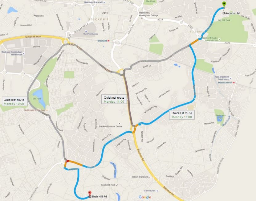
Not any more. A new feature in the Maps APIs called predictive travel times, will use historical time-of-day and day-of-week traffic data to estimate travel times at a future date. This makes it easier than ever to predict how long it will take to get somewhere and suggest the best route even when the departure time is far in the future.
I can think of some really interesting and innovative ways this could be used to help businesses engage with customers and improve efficiencies, for example:
Optimising route planning and delivery times
A parcel delivery company could schedule deliveries and provide estimated time of arrivals to customers to maximise the number of deliveries and reduce missed drops.
Mobile workforce management
A business with a mobile workforce could schedule jobs for workers and give them a departure time to ensure they reach jobs at the scheduled time. Arrival time could then be communicated to customers.
Travel planning as part of external application
A travel website could allow users to plan a day's sightseeing itinerary, calculating if they can see all the sites in a day and working out the optimum departure time to complete the itinerary.
Tracking companies
Tracking and telematics solution providers could add functionality to their solution, for example predicting when assets will arrive at their destination as well as improving scheduling modules.
There are many other potential uses for predictive travel time and I am sure you can think of a couple of innovative uses in your own business to help engage with customers, improve efficiencies and provide amazing customer experience. Let's get to work on doing this and making Google Maps even more valuable for your business.
Working with a Google Maps Premier Partner
A Google Cloud Partner like Ancoris can help you apply the power of Google Maps to solve current business challenges and develop new digital models using location-based services.
We’re not only a Google Maps Premier Partner but have achieved Google’s Location-Based Services Partner Specialisation. This means we’ve demonstrated both technical proficiency and proven success in building and managing applications using the best of Google Maps Platform and Google Cloud Platform in both web and mobile environments.
If you’d like to find out more about how we can help you, why not take a look at some of our customer success stories or talk to the experts in our Google Maps team.